
Have you ever wondered what a bottle of river water can tell us? It may look ordinary, but to a scientist, it’s like opening a mystery novel. it can reveal whether a coastal ecosystem is healthy, whether harmful algal blooms are beginning to form, and even whether fish and other aquatic life have enough oxygen to survive. Collecting that information requires far more than simply filling a bottle with water. It requires advanced technology, careful teamwork, and a race against time.
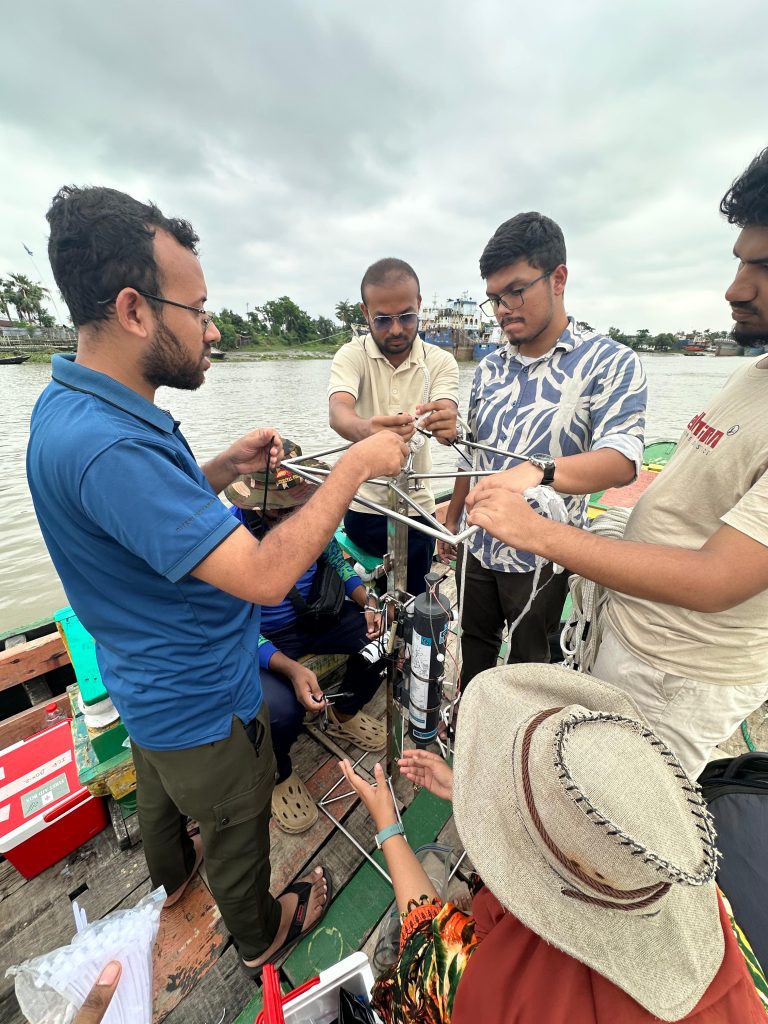
Hello everyone, I am S. M. Elman Reza Bhuiyan. Currently Working as a Research Assistant in GEM in a Box project under Nirmol Bangladesh. As a Research Assistant in the GEM-in-a-Box Project under Nirmol Bangladesh, supported by The Ocean Foundation, I recently had the opportunity to join a seven-member research team on a field expedition to the Rupsa River in Khulna. Our mission was simple collect high-quality water samples and environmental data that would help understand the health of Rupsa Rivers waters.
Our field equipment looked like something straight out of a marine research vessel. Together, the instruments were worth nearly US$19,573, yet what impressed me most was not their price, it was their capability. Despite their compact size, these instruments could measure an incredible amount of information hidden beneath the water’s surface.
Among all the instruments, the instrument that caught my attention, CTD Diver. I had worked with CTDs before, but they were large and bulky. This one was astonishingly small, about the size of a pen. Despite its small size, this continuously recorded temperature, conductivity, pressure, and depth with remarkable precision. It was a perfect reminder that in modern science, powerful technology doesn’t always come in large packages.
Our target was to collect water samples from both surface and 5m depth. To collect water from exactly 5 meters below the surface, we attached a Niskin water sampler, CTD Diver, and a PME miniDOT Dissolved Oxygen Logger to a specially designed metal frame that we built earlier. As the frame descended into the river, the Niskin bottle remained open, allowing water to flow freely through it. Once it reached the 5m depth, a trigger released the bottle’s end caps, instantly sealing water from that exact location inside. At the same time, the CTD and miniDOT quietly recorded measurements every minute. After spending five minutes at 5m depth, the frame was raised to the surface and held there for another five minutes so we could compare conditions between surface water and deeper water.
Surface samples were collected separately using a clean bucket before being transferred into carefully labeled bottles. Every sample was immediately stored inside an ice box maintained at approximately 4°C to preserve its chemical properties. During this expedition, we successfully collected samples from six monitoring stations along the Rupsa River.
Fieldwork didn’t go exactly as we planned. The biggest challenge we faced was the river’s powerful current. At times, it pushed the sampling frame so strongly that maintaining its position became difficult. Every deployment required coordination, patience, and teamwork to ensure that each sample truly represented the intended location.
Once the sampling was complete, the race against the clock started. Another challenge began with a 36-hour countdown.
Water samples cannot wait indefinitely. Nutrients and other chemical components begin to change naturally after collection, meaning delayed analysis can produce misleading results. Back at our temporary laboratory, the team immediately began processing the samples. Using a hand pump, we filtered each water sample before analyzing it with a spectrophotometer and centrifuge. Within this limited time window, we measured Total Dissolved Nitrogen (TDN), Soluble Reactive Phosphorus (SRP), and Total Silica (High Range), while data recorded by the CTD and miniDOT were downloaded and processed.
These measurements may sound highly technical, but they answer simple and important questions. Are there too many nutrients entering the river? Are microscopic algae growing excessively? Does the water contain enough oxygen to support fish and other aquatic life? When nutrients become too abundant, they can trigger rapid algal growth process known as coastal eutrophication. Although algae are an essential part of aquatic ecosystems, too much of something isn’t good. Excessive growth can reduce water quality and eventually consume the oxygen needed by aquatic organisms, threatening the entire ecosystem.
The Turner Designs Handheld Aquafluor Fluorometer helped estimate chlorophyll-a, an indicator of microscopic algae in the water. The miniDOT logger continuously monitored dissolved oxygen which is one of the most important indicators of aquatic health. Alongside these measurements, we also recorded turbidity. Total dissolved solids (TDS), electrical conductivity (EC) were measured using TDS meter. Temperature ere measured using Thermometer. Precise GPS coordinates using Garmin receiver. Together, these data create a detailed picture of the river’s condition.
Looking back, this expedition was far more than a day of collecting water samples. It was a firsthand experience of how modern technology, scientific precision, and teamwork come together to protect our coastal environment. Every bottle of water carried back to the laboratory represented valuable information about Bangladesh’s rivers and coast. Every measurement brought us one step closer to understanding and ultimately protecting the ecosystems that support our fisheries, biodiversity, and coastal communities.
Science often happens quietly, far from the public eye. Yet behind every dataset lies a team of researchers working long hours in the field and laboratory, ensuring that every sample counts. Through the GEM-in-a-Box Project, I was fortunate to witness that process firsthand, and it reminded me that safeguarding Bangladesh’s coastal future begins with understanding the water beneath our feet.